![](/images/other/stat-length.png)
![Excursión A pie Neustadt (Wied) - Route Strauscheid 1b Nordic Walking Neustadt (Wied) - Photo](https://media.geolcdn.com/t/1900/400/23673f5b-8e9e-4aac-bd57-d7ced4e8cded.jpeg&format=pjpeg&maxdim=2)
Route Strauscheid 1b Nordic Walking Neustadt (Wied)
SityTrail - itinéraires balisés pédestres
Tous les sentiers balisés d’Europe GUIDE+
![Longitud](/images/other/stat-length.png)
Longitud
3 km
![Altitud máxima](https://static1.geolcdn.com/siteimages/upload/files/1508320355ic_sort_altitude_max_24dp.png)
Altitud máxima
257 m
![Desnivel positivo](https://static1.geolcdn.com/siteimages/upload/files/1508320355ic_sort_den_pos_24dp.png)
Desnivel positivo
90 m
![Km-Effort](/images/other/stat-length.png)
Km-Effort
4,2 km
![Altitud mínima](https://static1.geolcdn.com/siteimages/upload/files/1508320355ic_sort_altitude_min_24dp.png)
Altitud mínima
163 m
![Desnivel negativo](https://static1.geolcdn.com/siteimages/upload/files/1508320355ic_sort_den_neg_24dp.png)
Desnivel negativo
70 m
![Boucle](https://static1.geolcdn.com/siteimages/upload/files/16400158638029165_repeat_loop_refresh_sync_direction_icon.png)
Boucle
No
Baliza
Fecha de creación :
2022-02-11 12:49:05.254
Última modificación :
2022-02-11 12:49:05.254
![A pie](https://static1.geolcdn.com/sitytour/trail-icons/100.png)
56m
Dificultad : Fácil
![Escanee este código QR para abrir la excursión en la aplicación SityTrail](https://capi.geolives.com/qq0zvz2zws4bq2lad0pu/sitytour/trails/3088025/qr.png?size=200)
Aplicación GPS de excursión GRATIS
A propósito
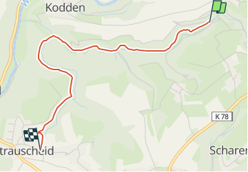
Ruta A pie de 3 km a descubrir en Renania-Palatinado, Landkreis Neuwied, Neustadt (Wied). Esta ruta ha sido propuesta por SityTrail - itinéraires balisés pédestres.
Descripción
Trail created by Neustadt (Wied).
Symbol: Weißer Nordic Walker auf hellblauem Grund
Localización
País:
Germany
Región :
Renania-Palatinado
Departamento/provincia :
Landkreis Neuwied
Municipio :
Neustadt (Wied)
Localidad:
Unknown
Salida:(Dec)
Salida:(UTM)
388235 ; 5607384 (32U) N.
Comentarios
Excursiones cerca
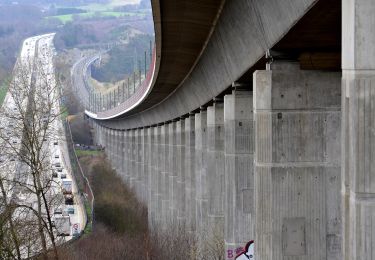
![Excursión A pie Windhagen - [W2] Windhagener Weg - Photo](https://media.geolcdn.com/t/375/260/adef9696-6d08-4cbb-94cd-bba75114ff6a.jpeg&format=jpg&maxdim=2)
![A pie A pie](https://static1.geolcdn.com/sitytour/trail-icons/100.png)
[W2] Windhagener Weg
A pie
Fácil
Windhagen,
Renania-Palatinado,
Landkreis Neuwied,
Germany
![](/images/other/stat-length.png)
6,9 km | 8,8 km-effort
1h 59min
![](https://static1.geolcdn.com/siteimages/upload/files/16400158638029165_repeat_loop_refresh_sync_direction_icon.png)
Sí
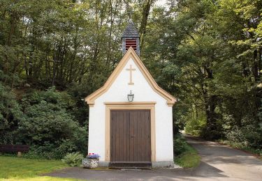
![Excursión A pie Asbach - [A2] Kapellenweg - Photo](https://media.geolcdn.com/t/375/260/cbe88fbf-390b-407f-8f63-05cd1398c451.jpeg&format=jpg&maxdim=2)
![A pie A pie](https://static1.geolcdn.com/sitytour/trail-icons/100.png)
[A2] Kapellenweg
A pie
Medio
Asbach,
Renania-Palatinado,
Landkreis Neuwied,
Germany
![](/images/other/stat-length.png)
18,8 km | 24 km-effort
5h 26min
![](https://static1.geolcdn.com/siteimages/upload/files/16400158638029165_repeat_loop_refresh_sync_direction_icon.png)
Sí
![Excursión A pie Breitscheid - Rundwanderweg Roßbach 1 - Photo](https://media.geolcdn.com/t/375/260/f2c11825-d560-4b0a-bc8e-3db9a2b40c70.jpeg&format=jpg&maxdim=2)
![A pie A pie](https://static1.geolcdn.com/sitytour/trail-icons/100.png)
Rundwanderweg Roßbach 1
A pie
Medio
Breitscheid,
Renania-Palatinado,
Landkreis Neuwied,
Germany
![](/images/other/stat-length.png)
17,5 km | 25 km-effort
5h 44min
![](https://static1.geolcdn.com/siteimages/upload/files/16400158638029165_repeat_loop_refresh_sync_direction_icon.png)
Sí
![Excursión A pie Neustadt (Wied) - [N1] Bertenauer Weg - Photo](https://media.geolcdn.com/t/375/260/23673f5b-8e9e-4aac-bd57-d7ced4e8cded.jpeg&format=jpg&maxdim=2)
![A pie A pie](https://static1.geolcdn.com/sitytour/trail-icons/100.png)
[N1] Bertenauer Weg
A pie
Medio
Neustadt (Wied),
Renania-Palatinado,
Landkreis Neuwied,
Germany
![](/images/other/stat-length.png)
17,6 km | 24 km-effort
5h 23min
![](https://static1.geolcdn.com/siteimages/upload/files/16400158638029165_repeat_loop_refresh_sync_direction_icon.png)
Sí
![Excursión A pie Vettelschoß - Vettelschoß Rundwanderweg R12 - Photo](https://media.geolcdn.com/t/375/260/b8c16d97-22d2-4b14-825c-d46874d740a8.jpeg&format=jpg&maxdim=2)
![A pie A pie](https://static1.geolcdn.com/sitytour/trail-icons/100.png)
Vettelschoß Rundwanderweg R12
A pie
Fácil
Vettelschoß,
Renania-Palatinado,
Landkreis Neuwied,
Germany
![](/images/other/stat-length.png)
4,9 km | 7,1 km-effort
1h 37min
![](https://static1.geolcdn.com/siteimages/upload/files/16400158638029165_repeat_loop_refresh_sync_direction_icon.png)
No
![Excursión A pie Neustadt (Wied) - N3 Neustädter Wanderweg 3 - Photo](https://media.geolcdn.com/t/375/260/e89ca6e9-1f21-4815-a33f-c9a8d227dac0.jpeg&format=jpg&maxdim=2)
![A pie A pie](https://static1.geolcdn.com/sitytour/trail-icons/100.png)
N3 Neustädter Wanderweg 3
A pie
Fácil
Neustadt (Wied),
Renania-Palatinado,
Landkreis Neuwied,
Germany
![](/images/other/stat-length.png)
10,7 km | 14,2 km-effort
3h 13min
![](https://static1.geolcdn.com/siteimages/upload/files/16400158638029165_repeat_loop_refresh_sync_direction_icon.png)
Sí
![Excursión A pie Windhagen - [W1] Stockhauser Weg - Photo](https://media.geolcdn.com/t/375/260/adef9696-6d08-4cbb-94cd-bba75114ff6a.jpeg&format=jpg&maxdim=2)
![A pie A pie](https://static1.geolcdn.com/sitytour/trail-icons/100.png)
[W1] Stockhauser Weg
A pie
Fácil
Windhagen,
Renania-Palatinado,
Landkreis Neuwied,
Germany
![](/images/other/stat-length.png)
8,6 km | 11 km-effort
2h 30min
![](https://static1.geolcdn.com/siteimages/upload/files/16400158638029165_repeat_loop_refresh_sync_direction_icon.png)
Sí
![Excursión A pie Neustadt (Wied) - N4 - Photo](https://media.geolcdn.com/t/375/260/23673f5b-8e9e-4aac-bd57-d7ced4e8cded.jpeg&format=jpg&maxdim=2)
![A pie A pie](https://static1.geolcdn.com/sitytour/trail-icons/100.png)
N4
A pie
Medio
Neustadt (Wied),
Renania-Palatinado,
Landkreis Neuwied,
Germany
![](/images/other/stat-length.png)
15,9 km | 22 km-effort
5h 4min
![](https://static1.geolcdn.com/siteimages/upload/files/16400158638029165_repeat_loop_refresh_sync_direction_icon.png)
Sí
![Excursión A pie - Rundweg Strödter Hügel - Photo](https://media.geolcdn.com/t/375/260/ddf8ebbc-05e3-45d3-ad79-f00655b4e165.jpeg&format=jpg&maxdim=2)
![A pie A pie](https://static1.geolcdn.com/sitytour/trail-icons/100.png)
Rundweg Strödter Hügel
A pie
Fácil
,
Renania-Palatinado,
Landkreis Neuwied,
Germany
![](/images/other/stat-length.png)
6,2 km | 8,4 km-effort
1h 55min
![](https://static1.geolcdn.com/siteimages/upload/files/16400158638029165_repeat_loop_refresh_sync_direction_icon.png)
Sí